Frequently Asked Questions
Data and functionality
What data is included in FiberLocator?
FiberLocator provides users with access to our growing database of fiber maps, lit building records,, data centers and internet exchanges, and Telco Central Offices, providing the visibility for companies to dynamically design and build smarter networks more efficiently and cost-effectively.
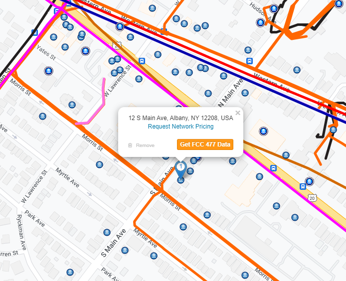
Our maps and data are detailed to street level and are ideal for sales and pre-qualification activities. For accuracy and security, our system does not offer engineering level information. Users can get the required detail for project planning from the carriers identified in FiberLocator.
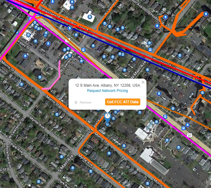
Aside from a street level view showing roads, FiberLocator also offers an aerial view of the map data. Users can toggle between the three available views at any time.
Can you tell me which carriers are in your database?
If you are looking for specific providers, you can type the name of the provider in the search box and you should see a drop-down list of that provider’s layer(s) if they’re available in the FiberLocator tool. You can also expand out the Metro Networks, and Long Haul Networks data sets by clicking on the down arrow on the far left beside the name of each data set.
Where do you get your data?
Our data is provided by the carriers that participate in the program. If you don’t see a carrier within the tool, you can make a suggestion and our data team will reach out to see if they’ll share their data with our users.
How often is your data updated?
The frequency of data updates is dependent upon the providers sharing their data. Many of the large providers and those that expect more frequent changes throughout the year provide monthly and quarterly updates. In addition, we are constantly adding new fiber providers, lit buildings and data centers. If you know of a provider that is NOT currently in FiberLocator, please send us their contact information.
I already have a system where I maintain network information. Am I able to integrate that with FiberLocator?
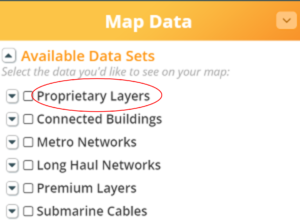
Yes, you have the ability to upload your own data into the database under the “Proprietary Layers” section. You can upload any of your own fiber research into the tool including sold circuits, shadow conduit, cell towers, lit building information, and more. This information remains private and viewable only to your account. Customers can submit GIS map files for line data (such as fiber maps) via kmz, kml or shp files, or submit address information for point data (such as lit buildings or data centers) via xls, or csv.
Pricing and demo
How can I get a demo of FiberLocator?
You can request a live demo session with one of our specialists to learn how FiberLocator will meet your specific needs.
How much does FiberLocator cost?
FiberLocator Online subscriptions are priced on a per-user, per-year basis. Please visit our store page for pricing and subscription details.
If you are with a large organization and need more than 16 users, we offer Enterprise level access and special pricing. Please contact sales@fiberlocator.com for pricing.
You can purchase a single snapshot, or a bundle of 3, 9 or 15 snapshots. Please visit the store page to learn more. All Snapshots are created by a FiberLocator Specialist.
Location & Map Services
Can FiberLocator be used for engineering projects or do you offer location services?
FiberLocator is a sales tool, not a “dig safe” or engineering tool. We can certainly provide fiber map data at most locations, but the information is for sales “pre-qualification” purposes and is not necessarily engineering grade.
Can I see ILEC and local cable companies' fiber assets?
It is rare to get maps from ILECs and MSOs, and as such FiberLocator does not show ILEC/local cable company information on a metro level. Thankfully, FiberLocator does have lit building information for various ILECs as well as some of their long-haul routes. When we do have a building list from the LEC or cable company, we can see their lit buildings among the available providers, and we can deduce that they have the ability to provide service in an area even though we can’t see the physical path of their network.
Can you tell me if there is fiber in the community where my house is located?
Unfortunately, we only have data for business addresses and not for residential class services.
What constitutes one map for your Single Snapshot?
The Single Snapshot map would be one PDF or PNG map of a specific address or location you specify. The view can either be street or aerial and both the data layers and zoom radius are selected by you. We typically generate the Single Snapshot while connecting with you through a live joint web session. This way you are able to view and customize the map as it is being generated to ensure you receive the map output you desire.
Do you offer an API?
Yes, FiberLocator’s API services give you access to our database of carrier fiber maps, lit building locations and data centers.
Additional information can be found on our API frequently asked questions.
Carriers & Data Centers
I work for a carrier. How do I get my information to you?
It’s easy to get your maps, lit buildings, and data centers in FiberLocator. Please contact our team here and then we will be in touch with you for additional information needed. There is no cost to you.
I work for a data center. How can I get my information to you?
Please contact our team here. There is no cost to you. You receive free exposure to well-qualified sales opportunities.


